Introduction: The Strait of Hormuz and Gulf Connectivity
While the world watches the Strait of Hormuz for its energy impact, for network engineers, the story runs deeper. This narrow waterway is a primary artery for international data, where a dense cluster of subsea cables follows the same channels that carry global energy. Today, these waters are increasingly defined by military activity, restricted navigation, and the resulting operational uncertainty.
The risk here isn't necessarily a total outage as the internet is architected to reroute. But a lot is going on in the connectivity front in the region right now. Cable routes are geographically concentrated, maintenance logistics now depend on safe maritime access, and major projects intended to add much-needed redundancy have reached a standstill. Simultaneous instability in the Red Sea and the Persian Gulf has created a rare "Dual-Front" scenario: both primary connectivity corridors are facing elevated risk at once. Some of the capacity and redundancy adding projects are getting interesting reroutes, and alternative solutions. All in all, it is a very interesting engineering scene right now, and we're covering the nitty-gritty details with maps, anecdotes, history and future in this article.
Disclaimer: The data in this article is compiled from publicly available resources and may contain errors. Maps and diagrams are for illustrative purposes only; they do not follow exact cable routes 100%, as the precise locations of certain infrastructure are often classified or commercially sensitive. To ensure a clear visualisation for this article, some technical data points may have been simplified or omitted.
Mapping the Gulf connectivity
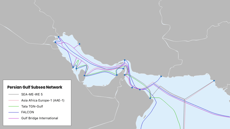
Much of the Gulf’s international traffic enters through submarine cables crossing the Strait of Hormuz, where systems share a narrow physical corridor before distributing connectivity across regional landing stations. Redundancy is currently achieved through a mix of five legacy "workhorse" networks. These systems are the backbone of the region, but under current conditions, they are being pushed to their technical limits.
The Legacy Workhorses of the Hormuz Strait
International connectivity into the Gulf typically follows a consistent physical layout. Submarine cables approach from the Arabian Sea and land first along the Omani coast, which acts as the primary "southern gateway" for the region. From these entry points, branching units (BUs) distribute capacity across the Gulf countries, connecting landing stations in the UAE, Qatar, Bahrain, Saudi Arabia, Kuwait, and Iraq.
Because regional cable permits historically favored routing through Omani waters, multiple systems follow closely aligned seabed paths while crossing the Strait of Hormuz. While logical diversity exists at the network layer—meaning data can be rerouted through different software paths—the physical routes are geographically very clustered. In the high-tension environment of April 2026, this clustering has transformed from a matter of convenience into a critical vulnerability.
Major systems transiting this corridor pictured:
- AAE-1 (Asia–Africa–Europe-1)
- FALCON
- Gulf Bridge International (GBI)
- Tata TGN-Gulf
- SEA-ME-WE 5
Let's look at the maritime cable systems one by one to better understand the challenges of the ecosystem:
- AAE-1 (Asia–Africa–Europe-1): A 25,000 km veteran of the region. Despite a history of frequent cuts in the Red Sea, it remains the primary legacy route currently forced to carry the overflow from newer, stalled systems. It is effectively the most congested "pipe" in the 2026 network.
- FALCON (GCX): A unique regional loop with landings in both the northern and southern Gulf. Its proximity to active maritime conflict zones in early 2026 has made it a high-risk asset, with repair vessels often unable to reach its northern segments safely.
- Gulf Bridge International (GBI): Known for pioneering the "North Route" through Iraq, GBI’s terrestrial rights-of-way are currently serving as the architectural blueprint for the region's emergency land-bypass projects.
- Tata TGN-Gulf: The primary enterprise link connecting the GCC to Mumbai. It is widely claimed to be operating at its maximum design capacity as it absorbs the traffic of corporate users who have migrated away from unstable Red Sea routes.
- SEA-ME-WE 5 (SMW5): A high-performance predecessor to the currently stalled SMW6. In 2026, it is likely operating in a "degraded" state due to unresolved electrical shunt faults in the Red Sea, where the security situation has prevented deep-sea maintenance for several months.
Once ashore, traffic moves through landing stations into terrestrial DWDM (Dense Wavelength Division Multiplexing) transport networks and national fiber backbones. Here, operators interconnect with regional Internet Exchange Points (IXPs) and upstream providers.
From an operational perspective, redundancy in the Strait was historically achieved through multi-operator capacity and routing policy. However, as of 2026, the industry has realised that this logical redundancy cannot compensate for the physical risk of a single narrow maritime corridor. There are a few alternatives, namely the red sea corridor and land routes - let's explore them next!
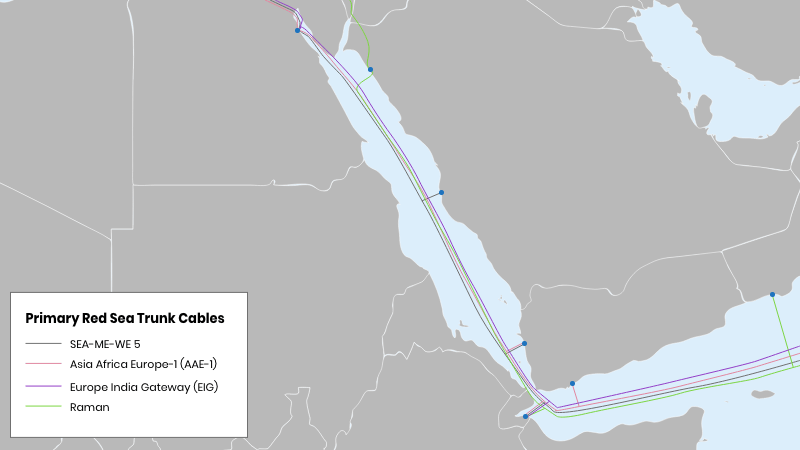
Alternative path: the Red Sea corridor
The primary alternative to Gulf routing is the Red Sea–Egypt corridor, which carries a large share of Asia–Europe traffic.This corridor hosts several major long-haul systems and functions as a parallel east–west connectivity path independent of Hormuz-based routing. Traffic entering the Middle East via Oman or Saudi Arabia can often be steered toward this route depending on operator capacity and peering arrangements.
In this model, cables run westward from the Arabian Sea through the Gulf of Aden into the Red Sea, then transition mostly across Egypt via terrestrial fibre before continuing into the Mediterranean and Europe.
The Primary trunk cables securing the connectivity across the Red Sea are:
- SEA-ME-WE 5 (SMW5)
- AAE-1 (Asia–Africa–Europe-1)
- EIG (Europe India Gateway)
- Blue-Raman
The current problem is that th instability in the Red Sea and the Persian Gulf has created a rare "Dual-Front" scenario: both primary connectivity corridors are facing elevated risk at once. As we'll observe when we explore each of these routes one by one, they're not an optimal solution to create redundancy for the situation at the Hormuz Strait:
- SEA-ME-WE 5 (SMW5): This system was designed for "matchless" low latency, but in 2026, it serves as a case study in the difficulties of conflict-zone maintenance. It has historically been plagued by electrical "shunt faults" in the shallow, high-traffic areas of the Red Sea. In the current environment, specialized repair vessels often cannot safely secure the maritime insurance required to enter contested waters. As a result, the cable is reportedly operating in a "degraded" state, with bandwidth restricted to prevent total system failure while repairs remain pending.
- AAE-1 (Asia–Africa–Europe-1): Often described by engineers as a "Red Sea Survivor," AAE-1 has remained operational despite a history of multiple cuts and regional disruptions. In the 2026 landscape, it functions as the overloaded artery of the Middle East. Because it is one of the few legacy systems with the scale to absorb traffic from the stalled 2Africa project, it is facing unprecedented congestion at its Egyptian landing stations, resulting in noticeable latency spikes for regional users.
- EIG (Europe India Gateway): A critical dependency for international enterprise data, the EIG is currently viewed as a high-risk asset due to its landing geography. Its path through the Bab el-Mandeb Strait—now a restricted military zone—means that any physical damage could lead to an indefinite outage. This vulnerability has made the EIG a primary candidate for emergency traffic migration onto Saudi Arabia’s terrestrial fiber backbones, which bypass the southern maritime chokepoints entirely.
- Blue-Raman: This Google-backed system is perhaps the most strategically significant cable in the 2026 environment, as it was explicitly designed to break the "Egyptian Bottleneck." By transitioning to land in Jordan and crossing to the Mediterranean via Israel, it avoids the Suez transit entirely. While other cables face delays or degradation, Blue-Raman remains a high-speed, operational outlier, though its unique geopolitical path requires constant security monitoring to maintain its status as the region's "Digital Lifeboat."
Now that we have looked into all the major submarine cables, it seems that we are coming to a conclusion where the problems are critical and geographically unresolvable in the two straits. And these straits carry most of the region's data highways. The natural next question is, what's going on on land?
Terrestrial data routes of the Gulf
In addition to subsea systems, regional operators are increasingly developing terrestrial fibre corridors designed to complement submarine connectivity.
These routes typically run:
- across Saudi Arabia’s national backbone,
- through Iraq toward Turkey and European networks,
- or via cross-border interconnects between Gulf states.
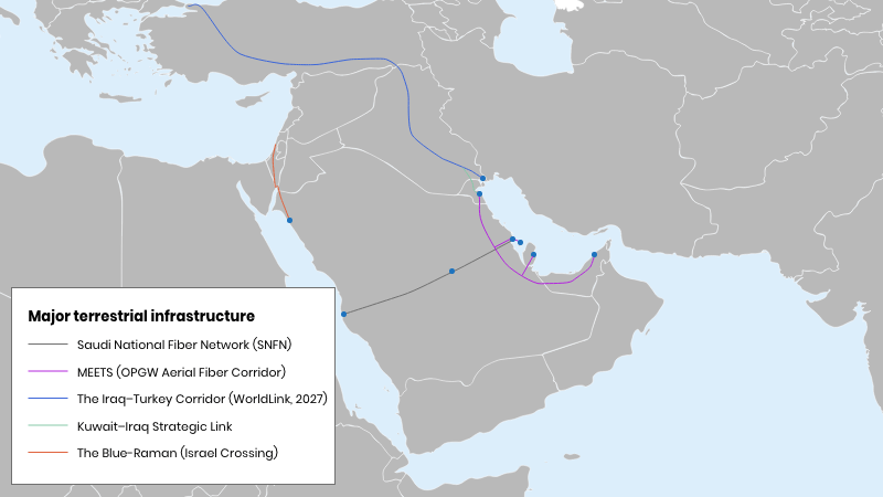
The shift from sea to land is a massive re-engineering of the Middle East’s geography. Here are the five key terrestrial corridors for regional connectivity, some of them operational and others under construction:
- SNFN (Saudi National Fiber Network): The SNFN is the largest terrestrial network in the region. Managed by STC, this sprawling system creates a high-capacity bridge across the Saudi interior. In 2026, its role is to act as the primary bypass for the Red Sea. Data that lands at the Red Sea coast is instantly tunnelled overland to the Gulf coast, effectively removing the need for data to transit the dangerous waters of the southern Bab el-Mandeb Strait.
- MEETS (Middle East-Europe Terrestrial System): MEETS is a unique 1,400km system that runs fiber alongside high-voltage power transmission lines. Unlike traditional cables buried in the ground, MEETS is an aerial network where the fiber is housed inside the uppermost shield wire of the power pylons. By running up in the air, the cable is far less prone to the accidental cuts or construction damage that typically plague buried lines, and it benefits from the high security of the regional power grid.
- The Iraq–Turkey Corridor (WorldLink): While the subsea portion of WorldLink remains stalled, the terrestrial segment has become a focal point of investment. This corridor seeks to transform Iraq into a global data hub, running fiber from the Al-Faw Peninsula northward through Baghdad to the Turkish border. Though the full project is officially targeted for 2027, emergency phases are already being activated to provide a Suez-free land path for traffic moving toward Istanbul and Frankfurt.
- The Kuwait–Iraq Strategic Link: This is a critical short-haul gateway that connects the internal Gulf networks to the Iraq-Turkey transit route. In early 2026, this link was significantly hardened to serve as the switch that allows data coming from the UAE or Qatar to jump off the Gulf's subsea systems and onto the safer Iraqi land corridor. It is the essential physical hand-off point that makes the entire "North Route" viable.
- The Blue-Raman (Israel Crossing): Google’s Blue-Raman project is the only system providing a 100% operational alternative to the Suez Canal today. The Raman segment lands in Jordan and transitions into a terrestrial fiber bridge that crosses Israel to reach the Mediterranean. In the 2026 landscape, this is the region’s digital lifeboat—the only route that bypasses both the Red Sea maritime zones and the Egyptian transit bottleneck.
The 2026 Force Majeure: halted and disrupted infrastructure projects
The current reality is a paradox of plenty: the seafloor is littered with billions of dollars’ worth of "mega-cables" that are 90% finished, yet the region is hanging by a thread, relying on aging, congested legacy systems that are literally breaking under the strain.
Let's look at the halted projects and the lost potential in the region's connectivity. Some of the very major projects include:
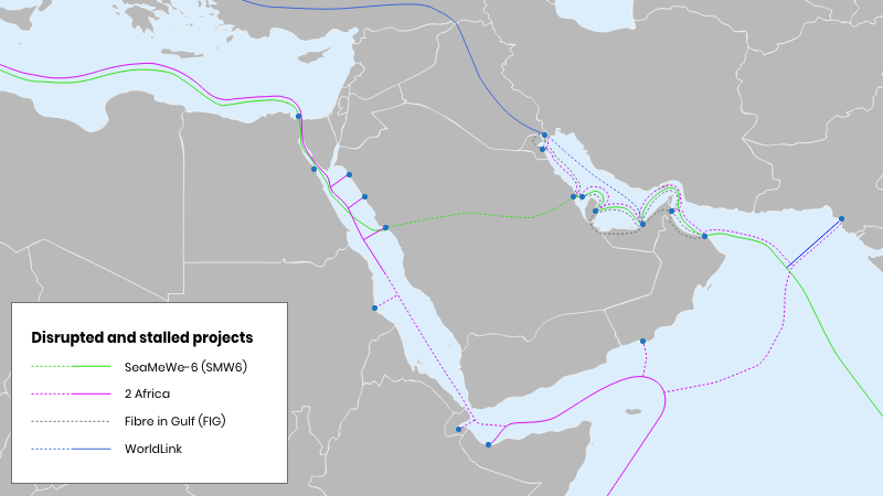
- 2Africa (Pearls Extension)
- SEA-ME-WE 6 (SMW6)
- Fibre in Gulf (FIG)
- WorldLink (Subsea Segment)
In the map below, the unbuilt or unconnected parts of the infrastructure are marked with dotted line:
Here are the most notable project disruptions explained:
- 2Africa (Pearls Extension): This project was supposed to be the "final boss" of Gulf connectivity. In March 2026, Alcatel Submarine Networks (ASN) officially declared Force Majeure after the Persian Gulf became a no-go zone. Most of the 2Africa Pearls cable is physically sitting on the seafloor right now, but the "landing" operations—the final 5km where the cable meets the beach—have been abandoned. The Ile De Batz remains laid up in Dammam, essentially a floating warehouse for a digital revolution that is currently on hold.
- SEA-ME-WE 6 (SMW6): SMW6 was designed as the high-speed replacement for the ageing SMW5. While the "eastern" and "western" ends are moving forward, the Red Sea Gap has turned it into a project in limbo. The consortium has been forced to postpone the Ready-for-Service (RFS) date to late 2027. This delay is catastrophic because it prevents the "unloading" of traffic from the degraded SMW5, leaving the region’s highest-demand route stuck on a failing legacy backbone.
- Fibre in Gulf (FIG): Originally Ooredoo’s crown jewel for local GCC connectivity, the FIG subsea loop is a victim of the "Strait of Hormuz Blockade." Construction was halted in early 2026 when maritime border tensions made cable-laying in the northern Gulf impossible. In a desperate pivot, Ooredoo formed OFN (Ooredoo Fibre Networks) in February 2026 to try to move FIG’s logic onto land, but the subsea "super-loop" remains a series of disconnected segments on the ocean floor.
- WorldLink (Subsea Segment): WorldLink is a tale of two realities. While the land corridor through Iraq is a success story, its subsea "Express" segment—intended to link the UAE directly to Iraq—is officially suspended. The project cannot secure maritime insurance for its vessels in the current northern Gulf climate. This leaves the land corridor as a "bridge to nowhere" until the subsea connection can safely link the UAE’s massive data centers to the Iraqi land pipe.
The 2026 conflict has done more than just delay construction; it has triggered a systemic failure of the region’s digital plumbing. While the land cables we’ve discussed provide a desperate "safety valve," they were never designed to handle the firehose of data that the region and the world demands.
Conclusion: The Maritime Standstill
In this article, we’ve explored how connectivity across the Gulf is built on a combination of submarine and terrestrial systems — from the tightly clustered cable routes in the Strait of Hormuz to the Red Sea corridor and overland fibre paths that provide alternative routing options. We’ve also looked at how several major projects intended to expand capacity and improve resilience are now on hold, delaying much-needed diversification of these routes.
From an operational perspective, the key takeaway is that resilience in this region is defined less by the number of cable systems and more by their physical distribution. Multiple networks may exist, but when they share the same corridor, redundancy has limits. When disruption occurs, traffic can and does reroute — but not without constraints in capacity and performance.
The more immediate concern is not a single failure event, but what follows. Submarine infrastructure depends on continuous maintenance, and in unstable conditions, even routine repairs can be delayed significantly. This extends the impact of otherwise manageable faults and reduces the system’s ability to recover within expected timeframes.
The Gulf remains connected, and the internet continues to function as designed. But the current situation highlights a fundamental characteristic of global infrastructure: physical topology still matters. Geography, access, and logistics ultimately define how resilient networks are — especially in regions where multiple critical paths converge.